Bring a location and a question. R.E.L.A.I. helps you explore renewable energy pathways; expert support helps you interpret the evidence and decide what to investigate next.
Angello’s animated walkthrough connects the scanner interface with solar screening, geothermal evidence, map layers and reporting concepts.
Video loads from LinkedIn when you click. Preview image shows the scanner interface. The demonstration includes features and development directions; available outputs vary by pathway. Screening and draft reports need specialist review.
At the end of the solar, wind or geothermal workflow, the web app offers a high-level site screening PDF summary. This records the initial assessment and next investigation steps.
For an extensive solar feasibility report with figures, analysis and conclusions, Geotechnic Report Factory is a separate multi-agent workflow. The scanner’s JSON export can provide inputs; generating its PDF summary does not generate the full report.
An early screen helps frame further investigation. It does not establish engineering feasibility, grid capacity, permitting approval, or an investment recommendation.
Read the layers together
A map is the start. The evidence shapes the next step.
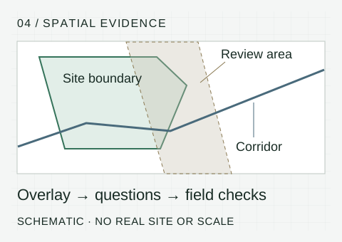
FIG. 04 / Spatial evidence · illustrative, not a site assessment
01 / Define the boundary
Use the project footprint to make the question specific. A location marker alone cannot describe the land affected.
02 / Read the intersections
Compare available layers and their provenance. A mapped corridor does not confirm available grid capacity; an environmental overlap needs investigation.
03 / Record what is unresolved
Separate observations, assumptions and missing studies. Agree which local checks and specialist input are needed next.
The guided start asks about your project decision, renewable pathway, role, main uncertainty, and intended output. Map tools let you define a site, with Basic and Advanced modes for different levels of detail.
Solar, wind, and deep geothermal pathways
Map-based site selection and spatial context
A starting point for a more focused technical conversation
For a scoped assessment, share your site boundary, project intent, available data, and the decision you need to support.
We agree the relevant evidence to review and the outputs: a concise technical brief, appropriate maps, key uncertainties, and recommended follow-up work.
“What should we investigate before taking this site further?”
Bring
A site boundary, intended energy use, available studies, and your main uncertainty.
Explore
Use the scanner to begin a screen. Identify which available observations address your question and where information is missing.
Review
Discuss an expert-supported brief that separates evidence, assumptions, and unanswered questions.
Act
Use the brief to plan local checks, specialist studies, or conversations with project partners. No result or suitability rating is implied by this example.
Specialist depth
Considering geothermal?
Subsurface evidence needs geological interpretation. We retain geothermal screening and technical review as specialist support, with explicit attention to uncertainty and further data needs.
Renewable developers and independent technical advisers assessing early opportunities. Municipalities and investors can also discuss a specific site question.
Can the scanner confirm grid access?
No. Nearby infrastructure does not establish available capacity, permission to connect, cost, or timing. Those need verification with the relevant parties.
Does every location have the same evidence?
No. Coverage, resolution, age, and relevance vary. Missing evidence should remain an open question, not be interpreted as a favourable result.
Can I use it on my phone?
The website is mobile-friendly. For detailed map interaction and site drawing in the scanner, use a desktop or laptop.
Start with one useful question
A site to assess. A workflow to improve.
Tell us what you are trying to decide, what information you have, and where the work gets stuck.