← Back to homepage
Geoscience · geology · geophysics

Subsurface intelligence for energy & critical minerals

15+ years of applied geoscience supporting exploration, geothermal, drilling, basin analysis and acquisition due diligence.

Geoscience service packages

Three levels of support — from rapid desktop interpretation to full technical due diligence.

Package 1🗺️

Quick subsurface scan

Fast geological summary for a licence, AOI or acquisition lead.

  • Well-log correlation overview
  • Key horizons & structural setting
  • High-level depositional insights
Package 2🔍

Interpretation brief

A deeper look for geothermal, O&G, CO₂ storage or minerals.

  • Stratigraphic & structural interpretation
  • 2D/3D seismic concept review
  • Play elements + risk summary
Package 3💼

Technical due diligence

Independent subsurface view for investors & acquisitions.

  • Data room assessment
  • Resource potential & uncertainty
  • Deal risks, red flags & value drivers

Geological & geophysical capabilities

Advanced subsurface workflows for exploration, geothermal and critical-minerals targeting.

🛢️Well-log interpretation
🧭Stratigraphic & structural modelling
🌐2D/3D seismic interpretation
📡Velocity modelling & depth conversion
🧠3D geomodelling (Petrel, Leapfrog)
📊Python-based analytics & QC

Seismic interpretation snapshots

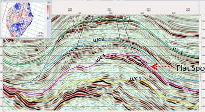
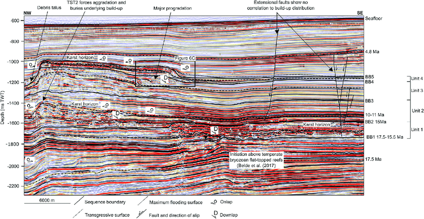
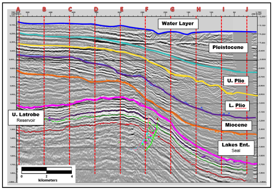
Hover over the thumbnails to reveal more detail — representative of the type of structural and stratigraphic insight you can expect.

Seismic line with structural trap interpretation
Structural traps & faults
Identifying traps, fault sealing and compartmentalisation for exploration and geothermal.
Stratigraphic onlap and pinchout seismic example
Stratigraphic plays
Onlap, pinchout and subtle stratigraphic features highlighted for reservoir presence.
Depth-converted seismic with horizons
Depth-converted sections
Depth-converted sections with key horizons, time–depth relationships and velocity QC.

Tools we use

Proven industry software across seismic, geomodelling and GIS, backed by scripting where it actually adds value.

Schlumberger Petrel
2D/3D geomodelling
Leapfrog
3D geology & volumes
ArcGIS Pro / Online
GIS & earth observation
QGIS
Open-source GIS
Google Earth Engine
Satellite time series
Earth Blox
EO workflows
FME
Data transformation
Python
Custom analytics & QC
Drs. Al Angello Pagano van Amersfoort
Lead geoscientist

Drs. Al Angello Pagano van Amersfoort

GIS / Geoscience Consultant · Venture Catalyst for Climate Startups · Founder of GeoTechnic.Solutions

Over 15 years in the global oil & gas industry followed by a pivot into geothermal, GIS and responsible resource development — bringing together structural geology, seismic interpretation and climate-tech venture experience to support the green transition.

  • Planned and supported multiple successful wells and field developments in the UK and Dutch North Sea.
  • Extensive consulting across South America, Europe and Africa on seismic interpretation and geomodelling.
  • GIS and EO projects for NGOs and climate organisations, including WWF and IRMA, focusing on deforestation, GHG emissions and responsible mining.
  • Proficient in Petrel, ArcGIS, QGIS, Earth Blox, Google Earth Engine and other tools, plus Python for automation.
  • Active mentor and venture catalyst for climate-tech startups.

Who we support

Practical subsurface decision-making for developers, operators and investors.

Explorers

De-risk new targets

Identify traps, reservoir presence and volumes before committing spend.

Operators

Plan efficient wells

Better pre-drill workflows, improved prognosis and reduced uncertainty.

Investors

Evaluate data rooms

Independent risk-based summaries for M&A, geothermal or minerals deals.

Need subsurface expertise?

Share your area, data room or project concept — we’ll propose a clear, actionable geoscience plan.

Book a geoscience session →